Summer Travels
2005
Click on State for write-ups & pictures
Flagstaff, AZ
Lowell Observatory
Oak Creek Canyon
Grand Canyon National Park, AZ
The Grand Canyon
Sedona, AZ
Chapel of the Holy Cross
Tucson, AZ
Pima Air & Space Museum
Old Tucson Studios
Williams, AZ
Spirit Ranch, Home of the White Buffalo
Japanese (Chinese) Tea Gardens
River Walk Boat Cruise
The Alamo
Mission San Jose'
Mission Concepcion
The Market Square
Las Vegas, NV
The Hoover Dam
Carroll Shelby Auto Museum
Madame Tussauds Wax Museum
Fremont Street Light Show
Siegfried & Roy Secret Garden
Springdale UT
Zion National Park
Bryce Canyon, UT
Panguitch, UT
Pioneer Days Celebration
Filmore, UT
Lava Fields
Brigham Young House
Mormon Temple
World Headquarters
Conference Center - Home of the Mormon
Tabernacle Choir Performance
Dempsey Springs, ID
Lava Hot Springs
Diggs, ID
The Spud
Idaho Falls, ID
Deer Lodge, MT
Old Montana Prison
Old Montana Prison Auto Museum
Hungry Horse, MT
Hungry Horse Dam
Lewistown, MT
Flathead Lake
Metis Celebration - (local Indian
celebration)
West Glacier, MT
Glacier National Park
Great Bear Adventure
Jackson Hole, WY
Devil's Tower
Moose, WY
Grand Tetons
Springfield, IL
Route 66 Festival
Abraham Lincoln Home
Abraham Lincoln Memorial
Shea's Gas Station Museum
Air Combat Museum
Deadwood, SD
Tatanda, Story of the Bison
Pell City, AL
Our campground
St. Louis, MO
The Gateway Arch
Video of construction
Museum of Westward Expansion
Ride to the Top
Cape Girardeau, MO
Murals
Back Home
We didn't do any sightseeing traveling from Florida to Texas.
June 2005 - Texas
San Antonio, Texas All Pictures
June 6, 2005
Today we took the City Tour of San Antonio. We were up and out by 8:30 AM to get the tour bus at the campground office. There were 12 people on the tour and the guide was funny, straightforward and very good. San Antonio is the second largest city in Texas and still growing. The city is modern but with the historic downtown still reflecting the old Spanish style buildings. As they say, big cities with a small town feel. There is such a diversity of cultures here from American, Mexican, Chinese, Mexican, and Spanish to Mexican. Yep, I think there is a Mexican Restaurant on every other corner.
Japanese (Chinese) Tea Gardens
These gardens were sculptured by a Japanese man out of an old lime rock quarry. As you enter through the gate, the name on the gate is “Chinese Tea Gardens”. Seems the gardens were finished just as World War II started and being Japanese the man didn’t want the gardens destroyed by well meaning Americans so he changed the name to Chinese instead of Japanese. Afterwards he gave the gardens to the city as a gift. However, for years when rebuilding and restorations were done in and around the city the gardens were forgotten and left to deteriorate. With no money and no buyers when the Mayor tried to sell it, the gardens were to be destroyed. This got the residents to band together to raise the funds and restoration has started. After entering through the gate you go up several steps to the Tea House. This is a large structure like an umbrella with five stone pillars supporting a wood beamed and thatched roof. You can see where vines and weeds were removed from the stone pillars but the roof’s wood beams are sagging and there are large gapping holes in the roof. There is now a three foot high fence around the Tea House for safety. Beyond the Tea House you follow stone walkways down into the gardens. The walkways and bridges are lined by stones and wonder through plants and flowers. The bridges used to go over lakes full of coy but today the bridges go over dry lakes as the guide said there is a leak somewhere in the lakes and they removed all the water and put the coy in the San Antonio River; even the waterfall is dry.
There was a special boat waiting for us when we arrived. The cruise takes you along the river passed all the restaurants and the manmade extension loop through the River Center Mall; the cruise lasted about 40-minues. The river is up to 12-feet deep and the manmade extensions are only 4-feet deep. It was a nice leisurely ride. Afterwards we went up stairs to the IMAX Theater to watch a 2D movie called “Alamo…the Price of Freedom”. We had reserved seats right up front on the second tier. The movie was pretty good and made you realize just how hard and bloody those 13 days were. After the movie it was lunch. We had 2-hours to eat lunch and see the Alamo so we ate in the food court of the Mall, sat outside for a little while to enjoy the sun and river before walking across the street to the Alamo.
The Alamo or Mission San Antonio de Valero as it was known was constructed in 1718 and was the first of five missions built by the Spanish friars in the San Antonio area. The battle took place in 1836 at the end of the Texas Revolution and all 189 men, including Davy Crockett and Jim Bowie, died holding their ground against 1,800 Mexican solders during a 13-day siege. The Chapel that is large, plain but beautiful and Long Barracks and the stone wall around the complex are all that remain today. Inside Long Barracks are artifacts from the battle including Jim Bowie’s knife and Davy Crockett’s rifle and several slats with the names of those men that died. The limestone walls are engraved with names of those men and when I asked the guide how many they counted, she only replied that there were lots and that an architectural student found one of the oldest from 1837 in the Bell Tower. Outside you walk into a well groomed garden with walkways taking you around the compound.
Mission San Jose’ is the largest and best known of the five missions. Built by the Spanish and inhabited by the Indians, it is fully restored. You enter through the stone walls where you can see the small holes through which the Indians would shout their guns and canyons. Yep, the Spanish even gave them guns and canyons to defend themselves. Inside are six acres with rooms where the Indians lived, wells, stone ovens and a few buildings used as mills. Toward the west end is the Church that houses the famous “Rose Window”. The guide told us that the Priest had a lover and the window, facing west, would always reflect the setting sun that would show where his quarters were so his lover could find it when she arrived. However, she never joined him but the legend lives on. However, the brochure says that the Rose Window or Rosie’s Window was done by the sculpture to honor his lover. The window called the Rose Window is the only wood trimmed window in the Church but is on the south side of the building and the guide told us that the window over the west entrance is the real Rose Window. Both are beautiful and are said to be the finest pieces of Spanish Colonial ornamentation in the country. The Chapel is beautiful and inside are rooms showing some of the original wall paintings. Outside the walls there is also a Visitor Center and Gift Shop.
Mission Concepcion is the oldest unrestored stone church in America today. There are no walls here and is much smaller than Mission San Jose’. The Chapel is much smaller but just as beautiful. Outside is a small yard that is being dug up to find the original foundations so it can be restored because the chapel’s limestone walls are cracking and deteriorating. I walked into a room in the back building and found a woman working on the wall. It looked like she was trying to restore the painting.
The Market Square
We left the mission and went to our last stop, the Market Square. Market Square is actually two buildings, one with 32 shops that’s a replica of an authentic Mexican market and the other with 80 specialty shops. The guide told us that the bakery in the Mi Tierra restaurant had the best sweetbread (pastries). We headed there first thing, got two pastries, sat down and enjoyed them in the bakery that had all kinds of piñatas hanging from the ceiling. We then walked around the market outside that had various clothing, jewelry and lots of piñatas.
San Antonio Zoo Pictures
San Antonio, TX - June 3, 2005
The zoo is a good size and houses over 3,500 animals. It is set in a former limestone quarry so all the animals roam in rocky natural settings. The animals we saw were birds, bears, lions, tigers, elephants, hippos, snakes, antelopes, and others. Most were trying to get some shade. We ate lunch in the small café, walked around the giraffes and monkeys and headed back to the motor home.
June 2005 - Arizona
Tucson, Arizona - Pima Air & Space Museum Pictures
June 17, 2005
Up this morning at 8:00 AM and it was already 93 degrees. High for today is to be 103 degrees. We headed out to the Pima Air & Space Museum just down Valencia Blvd. We purchased a “combo” ticket that admitted us to the museum and a motor coach tour to the Aircraft Maintenance and Regeneration Center (AMARC) facilities at Davis-Monthan Air Force Base. With 45-minutes before the motor coach tour we started the tour through Hanger #1 of the Museum. The museum is the World’s largest privately funded Aerospace Museum, has six buildings with planes and memorabilia and six acres of planes outside. Inside Hangar #1 we joined a tour and listened to the guide as we walked passed a replica of the Wright Brothers Plane, the “Timken” Learjet and a SR-71 Blackbird exhibit outside. The tour guide kept saying I’ll give you the shortened tour because of the heat but by the time we headed toward Hanger #2 it was time for the motor coach tour. This tour took us into the facilities of AMARC. The guide said there are 8,000 people working here and only eight are Air Force, everyone else is a government worker! This is where all the airplanes were we saw from the road yesterday. This facility has over 5,000 airplanes at a value when new of over $27 Billion. It’s not really a graveyard but rather a regeneration center. Arizona is ideal to store these planes because of the low humidity they don’t rust. There are over 5,000 planes sitting in the yards. I think we saw every kind of plane that was made! We even saw the Flying Fortress and the Super Guppy; boy, are these babies big. We saw Bombers, F-15, F-16, F-17 Fighters, Helicopters, Migs, Warthogs, B-52’s and Trainers, just to name a few. I can’t remember all we saw. You drive passed and look down rows and rows of planes, each covered by a special white vinyl type material. We saw some pretty strange planes and lots of ones being parted out. They take parts from several planes to refurbish others and can have any plane ready to fly between one week to one month time and the guide said they refurbished and readied 600 of these planes for Viet Nam and 150 for the Gulf War. All day there are planes flying overhead and supposedly all these planes are fueled and flown to keep them in condition. The tour lasted about an hour and was very good. After the motor coach tour we ate lunch in the Grill at the museum and continued our tour by walking around the buildings and yard, this time on our own. Each hanger has items dedicated to a particular group of flyers and was very interesting. Outside we walked around Bombers, Cargo Planes, Fighters, Seaplanes, Helicopters and Fire Fighters. I can’t believe we were walking around a huge gravel yard in 103 degree heat for an hour or more and not passing out. I really didn’t expect to spend all day here but it was definitely worth it.
Williams, Arizona - All Pictures
Williams is known as the “Gateway to the Grand Canyon” because that is where the Grand Canyon Railway departs to go to the Grand Canyon and Route 66 goes right through the center of the historic downtown. The whole town is on the National Register of Historic Places and all the buildings in the downtown district were built at the turn of the century and are some of the best preserved in Arizona. We walked over to the Grand Canyon Railway Station that was originally a Fred Harvey House. Fred Harvey was the mastermind behind The Harvey Girls that served visitors at the Grand Canyon Hotel in the 1890’s.
We drove west on Speedway to Gates Pass Rd. to get to the Old Tucson Studios. This is set up as an old western town where they made several movies. Inside the Town Hall they have displays of pictures of the movies made here and old movie camera and equipment. The other buildings were a Blacksmith Shop, Sheriffs Office, County Bank, Homesteader’s Cabin, Brewery, Train Depot, Bar, Grand Palace Hotel & Saloon, Cantina an Ice Cream Parlor. There was also a church, graveyard and a mission where they were doing a show when we got there.
Spirit Ranch, Home of the White Buffalo
I wanted to see the White Buffalo at the Spirit Ranch on SR-180. The White Buffalo is a sacred animal to the Indians that symbolizes peace throughout the world. There is no road that crosses between SR-64 and SR-180 so we had to drive 23 miles up SR-64 to Valle and turn down SR-180 south for another 31 miles to the Ranch. Jack didn’t like this too much. The Spirit Ranch has four adult white buffalo and two calves and three other buffalos that are not white. The buffalo are kept in pens that you walk around. The guy in the office told us not to take pictures of the big black buffalo or even lift my camera because people were teasing him yesterday and really riled him up, besides there were signs saying to stand four feet away from the fences. He was a big guy and I didn’t even raise my hands when we walked passed. As we started out the door to the pens, their black dog walked out in front of us and the woman said he would be our guide. Sure enough, he walked in front of us around all the pens and back to the office. The White Buffalo were lying down; they are not really white but more a cream color and definitely not the usual brown or black we saw before. The calves were not white either but a light tan; they change to the cream color as they grow. Well I saw them now, I’m happy! We drove back up SR-180 the 31 miles and back down SR-64 for 23 miles back to the campground; we got back quicker than going, at least it seemed that way. Thanks Jack.
Flagstaff, Arizona - Lowell Observatory All Pictures
Flagstaff, AZ - June 24, 2005
We drove into Flagstaff to see what was around. We drove up to the Lowell Observatory at 7,200 feet in the mountains. We arrived 30 minutes before a tour so we watched a short film about the observatory and the Astronomers who work there. They also have two display rooms about the starts and plants with some interactive exhibits and a gift shop. On the tour, we were taken into the dome housing the historic 24” Clark refractor telescope. This telescope is the oldest, biggest and best telescope made. They claimed that the two glass lenses were the most perfect hand-made lenses ever made and even today this telescope can not be beat when it comes to quality. It has a focal length of 32 feet, weighs almost two-tons and it can be moved by one person! The dome used to be moved by pulling on ropes but is now powered and rolls around on truck tires. However the doors in the ceiling are still opened by ropes. As powerful as this telescope is it can only view a very small area at a time and is for looking at things after they are found. So we continued on to the telescope that was used to discover the planet Pluto. This is the same type telescope but much smaller with a focal length of about 12 feet and is used to research the skies for new plants. We then moved on to the Exhibit Hall where there were displays of equipment, pictures and a library. They also have a telescope set up with the pictures taken of the planet Pluto. You look through the telescope and see each picture one after the other and notice that only one small speck seemed to have moved. That’s how the planet was discovered. The telescope takes a picture of an area and another one a week later; stars don’t move but planets do and in these two pictures you could see that one speck had moved. Now they plotted the small speck and used the 24” Clark to “focus in” on the planet. They still don’t know what Pluto looks like yet because it is still too far away. It would take you 226 light years to get there; that’s really far! They now have a new program in partnership with Discovery Channel to build an even more powerful telescope to further research our universe and beyond. We also saw the mausoleum of Warren Lowell, the founder of the Observatory. The view from the mountain of downtown Flagstaff is great.
Oak Creek Canyon, Red Rock Canyon, Chapel of the Holy Cross
Oak Creek Canyon is a canyon between the mountains with high spirals rising from the canyon floor surrounded by tall pine trees. All the mountains around the canyon are full of pines and made for a pretty scene. Further down the road is Red Rock Canyon and I do mean red rock. Large mountains of red rock rise from the canyon floor creating all kinds of formations. We drove down I-179 for about three-miles to the Chapel of the Holy Cross. This chapel was completed in 1956 twenty-five years after its conception by artist and sculptor Marguerite Brunswig Staude. It is built on a twin pinnacled spur, about 250 feet high and juts out of a thousand foot rock wall. To get to the chapel you have to walk up a long spiral walkway. The inside is a simple chapel with large beautiful floor to ceiling twin windows overlooking the mountains and valley.
The Grand Canyon, Arizona Pictures
Grand Canyon, AZ - Jun 26, 2005
It was a nice drive to the south rim of the Grand Canyon. We walked up a concrete trail to Mather Point. What a view! We walked all over the area taking pictures but it was a little after 2 PM and the Canyon was washed with light that didn’t create any shadow at all and it looked washed out. Looking out across the Canyon or down into the Canyon your perspective is totally off and you really can’t tell just how far across or how far down the floor of the Canyon is. The North Rim is just 10 miles across the canyon as the raven flies but 216 miles around the east end driving. And to think that from any point at the South Rim you can only see one-third of the entire Canyon. There are three shuttles that take you around the Park; the Blue Shuttle that goes from the campgrounds and hotels to the Village; the Green Shuttle that takes you along the Kaibab Trail Route; and the Red Shuttle that takes you along the Hermits Rest Route. Most routes are closed to private vehicles and only accessible by the shuttle system. We took the Blue Shuttle to Mather Point and caught the Green Shuttle that goes on the Kaibab Trail Route to go out to Yaki Point for the sunset. This shuttles stop at four or five overlooks before getting to Yaki Point. You can get off and catch the next shuttle that comes every 15 minutes. At South Kaibab Trailhead we got off and walked around taking pictures. Most of the area is natural, without railings and lots of loose gravel so if you are not careful you could fall off real easy. I don’t know if anyone has fallen off the cliffs but they rescue 250 people each year from the Canyon floor. The sun was setting and made shadows in the Canyon; boy what views. They also have stables here for the horse and mule rides. We caught the next shuttle to Yaki Point which is the furthest point on the South Rim. I walked over to the far end and saw some guy sitting on the rocks above a tree watching some black ravens. The sun was slowing setting and the Canyon colors were showing up. Back on the shuttle to Pipe Creek Vista, the third stop on this trail. Once again we walked wherever we could taking pictures. It’s unbelievable and the shadows help to define the canyon. Back at the Visitor Center we walked across the plaza back to Mather Point to watch the sunset. There were lots of people doing the same thing. Both Mather Point and Yavapai Observation Station were packed with people. One person was even further out on the point sitting on the rocks where it was hundreds of feet straight down. Boy does he have nerve. The shadows brought out the orange and green colors of the canyon but the further the sun set the greyer the canyon got. All the color was gone and all definition was gone! Not what I expected. Around 10 PM we took a look outside at the stars and WOW! So many and you can even see clusters like the Milky way.
The next day we drove on the Desert View Drive, SR-64, to Desert View Point, 25 miles from the South Rim and at a height of some 7,438 feet. This is also the East Entrance of the Grand Canyon. The prettiest views of the Grand Canyon were from here. You can see most of the Canyon and it was beautiful. There is a Marketplace, a Bookstore and a Trading Post with all kinds of gift items. A blacktop trail leads down to the Watchtower and the observation point. The Watchtower is a large circular tower built entirely of rock and said to have been a place for food storage and to observe the havens. You can walk inside and up four flights of stairs winding around the inside. On each floor there are windows overlooking the Canyon and paintings and decorations on the walls. Each floor is open in the middle down to the first floor. From the second floor you can walk outside on a deck like area that has a large fireplace at one end facing the Canyon and a large round table in the middle. I have no idea what the table was for but if this was for food storage I’d imagine it was used to cut up the meat. At the observation point you can see what seemed like the whole length of the Canyon, but of course it isn’t. This place has the one of the best viewing spots we’ve seen yet. We continued on to Navajo Point, Lipan Point, Moran Point, Grandview Point and Yaki Point. Each stop gave us a little different view of the Canyon and some spectacular views but the sun was high in the sky and I think the pictures may be washed out and the definitions of the Canyon will be lost. The drive was really nice and the day couldn’t have been better, with a temperature of 78 degrees and sunny.
July 2005 - Nevada
Las Vegas, NV - Pictures
July, 2005
We spent a little over a week here and boy did we have fun. We tried out every casino, ate at every buffet and watched several shows that were great.
The Hoover Dam & Lake Mead Pictures
Las Vegas, NV - Jul 8, 2005
We then drove to the Hoover Dam. We first parked on the Arizona side but it was just too far from everything and it was too hot to walk back over so we moved and parked in the Parking Garage near the Visitors Center. We took the Discovery Tour of the Dam that started with a slide show presentation and information about the dam. The dam is 726 feet high and is one of the highest concrete dams ever constructed. The Colorado River would surge in summer when the snows melted and flood the low-lying land and dry up again in early fall, leaving no water to irrigate the farms. The Hoover Dam was built to control this flooding and drying process and create a year-round water supply; the electricity is a by-product. Begun in 1931, the last concrete was poured in 1935. President Hoover, for who the Dam is named, advocated that the Boulder Canyon Project (name of the project authorizing the dam building) be self-supporting, financed entirely through the sale of hydroelectric power generated at the dam and is still operated and maintained with revenues from the power sales today. The plant generates more than 4 billion kilowatt-hours a year for use in Nevada, Arizona and California. One interesting fact is that none the electricity generated here is used by the city of Las Vegas; they get their electric power from a coal burning plant further north. Next we took an elevator down 500 feet to where the generators are. There are 8 generators that are huge and there are hundreds of electric transformers all over the mountains. From the generator room we went back up to the Observation Deck. The guide there told us where the state line was and other information about the dam. The guide also told us that in August the temperatures on the Observation Deck could reach 120 degrees. I believe it, it was really hot up there. Next we walked across the street to the two statues. These are brass but are left to tarnish to show age just like the dam and were sculptured to represent the men who built the dam but to show them as more than just man but as “super men”. Each statue is a figure of a man with up-stretched arms with wings, is unpolished brass and 50-feet tall. The guide said that if you rub the toes of the statue and gamble you will win. Yea right! I rubbed them anyway. We also took a tour of Lake Mead on the Desert Princess Paddlewheel boat . It has three decks, the top deck having no shade and at 109 degrees that sun was really hot. The cruise went around the lake and close to the Hoover Dam, which only looked like a large wall of concrete with two towers. Lake Mead is America’s largest man-made reservoir. It can store 28.5 million acre-feet (9.2 trillion gallons) of water or two years of the river’s average annual flow. The water is a beautiful emerald green with mountains of various color rock. You can see a definite line all the way around the lake where the water should be; the mountains are colors down to this line and the rest of the way to the water is white like the rocks were bleached. This bleached area is at least 10 to 12 feet long so the lake is very low due to the draught. The cruise lasted 90 minutes and the disappointing part of the cruise was not being able to hear the narration; the speakers were very very low and you couldn’t hear anything.
Carroll Shelby Auto Museum Pictures
Las Vegas, NV
Carroll Shelby manufacturing plant. They only give tours in the morning and we were too late for that but we could walk around about 15 models of Mustangs in the showroom. They had some GT 40’s and a couple cobras; one being the original 249 cobra. Jack enjoyed it.
Madame Tussauds Wax Museum Pictures
Las Vegas, NV
This museum has all the wax figures standing around a large room as if at a cocktail party and you are encouraged to touch and pose with each figure and even take a picture of you with Elvis before you exit. You also walk through a room that shows you how they measured each celebrity to get the details of their face for the wax figures. They had everyone from the President, George Bush, George Burns, Bob Hope, Basketball players, football players to the Rat Pack. There were people taking pictures dancing with Patrick Swaezy and golfing with Tiger Woods. The figures were pretty good too.
Fremont Street Light Show Pictures
Las Vegas, NV
Fremont Street has a large canopy over top the street and makes it look somewhat like a tunnel or huge train station platform you walk under that is covered by millions of lights and every night there is a light show, you stand in the middle of the street and look up! We caught the last 5 minutes of the show and there wasn't another one until a hour from now. Disappointing, I thought it went on all night.
Siegfried & Roy Secret Garden Pictures
Las Vegas, NV
The Mirage is home to the Secret Garden of Siegfried & Roy White Tigers. After a guide explained the garden layout and safety rules I walked down to three pools housing dolphins that are used for research. The handlers do have them do some simple tricks for the audience and you can also go down under the pool to see them. After seeing the dolphins, I walked behind the pools following a pathway going through lush gardens coming up to lush natural habitats where the white tigers are. Each area is large and lush with six white tigers, four with dark stripes and two white with very light stripes. They were beautiful and really big. Another area housed three white lions, two female and one really big male with a huge mane. This guy’s paw was the size of my entire head. Further on was a Siberian Tiger, a malamute, a leopard and an elephant. Even though this whole area is outside it was a little cooler in the garden. I didn’t realize I was in there for almost an hour; Jack was wondering where I was. Silly him, he should have known when it comes to cats, I don't hurry.
July 2005 - Utah
Zion National Park Pictures
Springdale, UT - July 16, 2005
Zion is Utah’s oldest National Park. The colors of the rock formations change from red rock to black lava rock to white sandstone, some containing all three colors. From the Visitor’s Center we took a shuttle that runs every 7 minutes. First stop was the Zion Museum. This museum has a 27-minute film about the Park and an open museum with story boards you walk around. We then caught the shuttle and stayed on until the end at the Temple of Sinawava. The shuttle makes stops at seven trailheads with trails anywhere from ½ mile to 16 miles to see towering sandstone cliffs some up to 3,000-feet high with names like the Angels Landing, the Three Patriarchs, the Great White Throne and the Bee Hives. We stayed on the shuttle because at 114 degrees and it was just too hot to do any walking on desert trails. At the last stop we got off and walked a few hundred yards to the Virgin River. This river is responsible for carving the canyon with it's clear and cold water. There were lots of people swimming and just enjoying the water on such a hot day. The shuttle guide said that the Narrows were down a trail 1 mile from here and the pictures I’ve seen were just spectacular and I really wanted to see them. We started walking down the trail that was all concrete and brick. Jack thought I was nuts for going but he followed until we reached an overhang with lots of shade. He stayed there while I continued on to the end of the trail. The trail follows the river with several nice shady places to dip your feet but ends at a large rock wall with steps down to the river. To continue you have to walk up the river! I walked to the water’s edge and tried to see but the river curves around a corner and you can’t see anything from this point. Of all the streams and rivers we’ve seen in the area that were dry, this one had to be at its normal level with rushing water. I looked to see if there was a way I could walk along the sides but they were shear rock and everyone I saw in the water was up to their waist. I was not prepared for this and just didn’t want to take the chance trying to navigate the rushing water while trying to keep my pocketbook and camera dry. If I had known I had to wade up the river I would have left my pocketbook with Jack and brought an extra pair of sneakers. Really disappointed I headed back. Jack was waiting for me and after a short rest, we continued back to the shuttle and the Visitor’s Center. I found out later that the trail goes for 16 miles through the Narrows and you need a permit, which I didn’t. I also heard from some people that people have been badly injured here. So I guess I was glad I couldn't continue.
Bryce Canyon Pictures
Bryce, UT - July 21, 2005
South of US-89 to SR-12 to SR-63 into Bryce Canyon. Along SR-12 within the Dixie National Forest is Red Canyon for several miles with impressive red rock cliffs, spires and large columns of rock called hoodoos. We even went through two short tunnels cut through the red rock. Bryce Canyon is one of the best places for star gazing because it is so dark and the air is a lot less polluted but we didn't get a chance to see because it was overcast while we were there. At one of the overlooks called Natural Bridge there is a large bridge or arch that was created by erosion of wind and water. It was really pretty and something to see. All the other overlooks gave you a slightly different view of the spires and hoodoos of the area. The entire route is only 18-miles and ends at Rainbow Point.
Pioneer Days Celebration Pictures
Panguitch, UT - July 23, 2005
This weekend the entire state of Utah is celebrating Pioneer Days, celebrating the first settlers coming to the area. Panguitch was having a parade this morning that ended right up the corner, so we grabbed our chairs and walked up the corner. There was one fire truck, three tractors, two marching bands, several floats and three old cars. The entire parade lasted 45 minutes! There is a Deep-Pit Barbecue at 12:30 PM, races and games for kids at 2 PM and the finals of the Invitational Rodeo at 7 PM.
Red Rock Canyon Pictures
Panguitch, UT - July 23, 2005
The only road through the park is the scenic road that runs 13 miles around the red rocks and limestone foundations. It was interesting and the contrast between the red rock and grey limestone was interesting. The drive goes through Dixie National Forest and is a very nice ride. The lake is absolutely beautiful.
There are several campgrounds around the lake and houses being built on the hillsides. We stopped at one campground that is right on the lake to inquire about services. Surprisingly they have full hook-ups and charged $22.50 a night but the place leaves much to be desired. The sites are close and there are all kinds of old trailers, etc. around. We drove a little way around the lake but turned around because of dirt road access only. We drove back up Route 143 and stopped at several spots to check out the river. There are some really pretty places along the river and one spot the river splits where you can walk across it. We’ll have to come back again later with our water shoes. We saw several fishermen along the banks. At one spot, the river cut a deep ravine in the rocks what seemed to be 100 feet deep. It looked like a pretty big thunderstorm is on its way, you can see the large thunderhead all around us and there are a few drops here and there. We drove back to Rt. 89 to our campground.
Lava Fields Pictures
Filmore, UT, July 27, 2005
We took a ride down Rt. 100 for five miles onto Rt. 1100 to a gravel road that ran along the lava field. This lava is from the now extinct volcano in the Great Basin that used to be the Bonneville Salt Lake many many years ago. We got out and walked over to the lava field and even picked a piece of rock up; it was surprisingly heavy. The lava field was like looking at a bunch of crumbled up Oreo cookies without the cream center; all black or dark rock sprinkled across the landscape. I read that if you break open the lava rock the inside could be colors of red or orange but we couldn’t break any open. It was really eerie the way it just stopped and bushes, grass or weeds continued. This field went for at least six miles and I have no idea for how wide. We didn’t drive the entire length of the field because the road was just too dusty with broken up gravel.
Salt Lake City, Utah All Pictures
Salt Lake City, UT
We took a ride downtown and walked around Temple Square and took a tour of the Conference Center. The building encompasses four acres and is the largest building in the world that is not supported by any poles or supports inside to obstruct your view of the stage. Instead there is a huge support beam that is 50 plus feet long and 8 feet wide to support the entire structure without additional supports inside. The building seats 21,000 people in the Hall and 900 people in the theater in another part of the building. The building was built by three contractors because no single contractor would take the job. There have been numerous designers and engineers that are amazed at its construction. The entire stage and boxes where the choir sits are modular units that can be taken apart to open up the area to produce a very large stage. There is an art gallery in the complex with original paintings. The roof is four acres of gardens full with wild grasses and native flowers and even trees. There is a large fountain in the middle that overflows down four channels leading to the edge of the building then cascades down the building’s five stories to the street below. There are also eight skylights. This is where the Mormon Tabernacle Choir performs now because the Tabernacle is being renovated.
Temple Square covers 35 acres of gardens around the Squares buildings. I walked around the Temple, a beautiful building with six towers topped by spires so high I couldn’t get it all in one picture. No tours are allowed inside so I walked around outside and watched as at least five wedding parties took their pictures. One guide told me sometimes they have 25 weddings there in one day. The Temple is surrounded with beautiful flower gardens. I then walked into the Joseph Smith Memorial Building. I didn’t watch the hour-long film in their theater but did walk through the Family Search Center where anyone can use the computers to find information about their ancestors. The lobby was spectacular with high glass engraved ceilings, one huge glass crystal chandelier and marble pillars. Statues, a grand piano, large comfy looking couches and palm trees on a large oriental room finished the room. They have two observation decks on the 10th floor and also two restaurants. The decks are enclosed with windows more like a sitting area but the view of Temple Square was great. A woman told me to go into the Church Office Building and ask to go to the observation deck on the 26th floor to get an even better view of the city. So I walked over to the second highest building in Salt Lake City, the headquarters for The Church of Jesus Christ of Latter-day Saints. A woman takes you up a locked elevator to the 26th floor and stays there until you are ready to go back down. The observation deck is outside surrounded by a four-foot wall with plastic “windows” on top. Talk about a view! You are above everything.
I saw the Capitol building that is under reconstruction and the entire four acres of the Conference Center. The views of the Temple are also great and from here you can see the entire Salt Lake Valley. There are a few holes in the plastic so you can put your camera through instead of getting pictures of finger prints. Good idea.
Mormon Tabernacle Choir Performance
I saw a live performance of the Mormon Tabernacle Choir’s “Music and The Word” at the Conference Center. The elevator brought me right up to the fountain outside the Hall doors. Inside thousands of people were coming in. They allow you to take as many pictures as you want before the broadcast and that’s exactly what everyone was doing. The choir was already rehearsing for the broadcast and they ran through the program. By 9:15 AM there must have been 3,000 people in the Hall and the doors were locked. The announcer welcomed us to the broadcast and told us a little about the Center. Everything is being done at the Center because the Tabernacle is under retrofitted with better construction because of 911. The Conference Center covers 36 acres and you could fit three Tabernacles inside it. It seats 21,000 people and was built to hold the semi-annual church conferences. It may not be the largest building in the world but it is the largest that is designed without supports inside to obstruct your view. The audience is not involved in the broadcast and we were asked to be as quiet as possible, not to applaud until after the broadcast is over and to turn off all cell phones and cameras, no pictures please. He introduced a few people and groups that were there and the Mormon Tabernacle announcer. At 9:30 AM the entire Hall went quiet and the broadcast began. The lights of the camera turned on and introductions were run on two large monitors on the walls. The entire broadcast was the announcer reciting “Anticipation” in between several songs sung by the choir. The announcer ended the program and the cameras shut off. It was great!
The broadcast is the longest continuing network broadcast in the world. The choir has 360 volunteer members, performs worldwide and has released more than 150 albums, including five gold and two platinum. The first radio broadcast was in 1929 and is now broadcast over approximately 2,000 radio, television and cable stations worldwide. However, the full-symphony orchestra only started in 1999. The organ is massive and has 8,000 pipes and sounded really great. The original Tabernacle organ has 11,623 pipes; wow, I sure wish we could have heard that one.
August 2005- Idaho
Lava Hot Springs - All Pictures
Dempsey Springs, ID
They have two heated swimming pools, an Olympic size pool with racing lanes and a 10 meter diving tower. There are also two tube slides. The springs themselves is now a complex with four outdoor pools each at a different water temperature. The springs were created by an ancient volcano that now delivers 2-1/2 million gallons of hot spring water that circulates through four pools. The water has no chlorine or Sulphur and there is no odor at all. They charge to go into the springs so we just looked and continued up the street. There must be four or five places you can rent rubber tubes for floating down the river that runs through the town. There were lots of people carrying tubes up the street so we followed them and watched as they came down the river and over some really tough rocks and a small waterfall. Hey what do you know, there was a big banner over the street saying BINGO every Wednesday and Friday, Lions Club. Guess what I'll be doing tonight.
Driggs, ID
Driggs is another small western town with some neat looking old buildings but modern stores inside. One building on the corner had a buffalo on its roof; it was a seafood and steak restaurant called the Gourmet Pantry. Driggs also has a old drive in movie called The Spud. You know, Idaho potatoes.
Idaho Falls, ID
The Snake River runs through the downtown area and is part of a dam built to supply hydroelectric power for Idaho Falls. The falls is actually a concrete wall extending into the river and splitting it in half for several miles; the river “overflows” over the wall and rocks at its base. There are walkways on both sides of the river in a park-like setting that goes for miles; we walked along the one side for a little while before turning around at the bridge.
August 2005 - Montana
Deer Lodge, Montana - Old Montana Prison All Pictures
The Old Prison was built in 1912 and used for 108 years. Inside the 23-foot high stone walls was a kitchen, bakery, workshops, chapel, library besides the three-floor cell block, showers and the “hole”. There was also a Woman’s prison that was used for maximum security facilities. The cells were small 4x6 cells with sink, toilet, writing desk and bed and nothing else. The “Hole” or “Black Box” was just as small with no light at all and nothing else. On the same property was a theater that must have been quite beautiful in its day but now is in total disrepair and where they display the gallows.
Old Montana Prison Auto Museum
We walked through 120 cars from classic Chevys and muscle cars to Model T's.
Glacier National Park Pictures
West Glacier, MT - Aug 2005
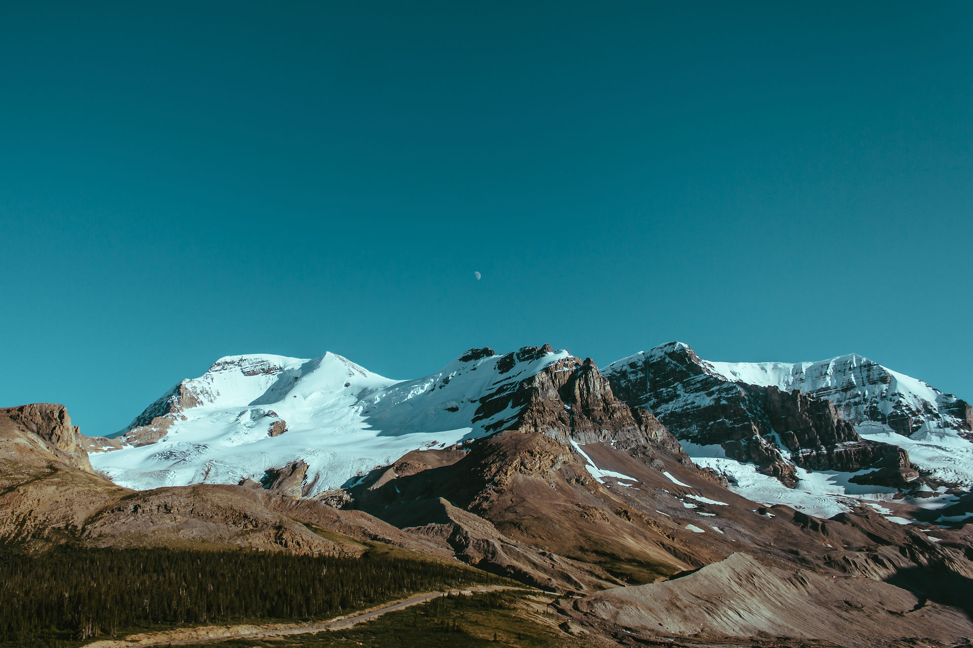
We drove into the West Entrance. There is only one road that goes completely through the park from the West Glacier Entrance to St. Mary at the East Entrance, a 55 mile two lane road called Going-to-the-Sun Road. The road is blacktopped, windy and narrow in spots and has fantastic views of the mountains. There is a 21-foot maximum length for any kind of trailer or motor home but we were in our car so it didn't matter. We first drove along the shores of Lake McDonald, a 10-mile long, 492-foot deep emerald green lake. You can rent boats or take a tour boat around the lake. When we were here two years ago we couldn’t stay because of the fires. Today there are no fires but you can see acres and acres of hillside with burned trees and no color but grey or black. There was a sign at one of the overlooks pointing out the whole area across the lake that was scorched by the fires. It was August 10th, 2003 when it all started. Further along the road you double back around the Loop and passed the Weeping Wall; this is simply water seeping out of the mountains right along the side of the road. We then approached Logan Pass Visitor Center at 6,646 feet in elevation. The Visitor Center is where you can hike a trail that goes along the mountain base at 9,553-feet called the Garden Wall. Lots of people were walking up the trail but it must have been 48 degrees and a strong wind was blowing so it’s not for us. The Continental Divide also runs through the Pass here. The mountains are just gorgeous, high rugged peaks topped with snow.
The road from here turned from blacktop to gravel. We have seen lots of cars in the parking lot at the West Entrance just covered with dust and dirt, now we know why. Not only was the road gravel but there were two places where the road was under construction. Fortunately each was less than a mile and we had only a 4 or 5 minute delay. Jack suggested turning around here and heading back but not me, this was only half way through the park and I hate to miss anything; so on we went. We stopped at an overlook for Jackson Glacier. Yes, this is a real glacier millions of years old. They said it is melting and shrinking more and more each year. After that the road follows along Saint Mary Lake for 12 miles. This lake is a beautiful turquoise color and crystal clear. One spot we stopped called Sun Point is a picture perfect spot; a beautiful lake surrounded by forested mountains on both sides and larger mountain peaks topped with snow in the background. What a heavenly sight!
We approached the East Entrance Visitor’s Center, turned around in the parking lot and headed back to the West Entrance. We drove 55.5 miles to get here. The scenery heading west is just as beautiful and magnificent as heading east.
Flat Head Lake All Pictures
West Glacier, MT - August 26, 2005
There's just something about this area that produces the absolute best red cherries I have ever tasted. I bought so much I made myself sick.
West Glacier, MT - August 26, 2005
You drive through the park because the bears roam free. They tell you to keep all doors and windows closed and locked and not to open them to take pictures without permission from the rangers. We saw two rangers but didn’t really need to open any windows because we only saw four bears and they were busy doing their thing. One bear was lying on his back occasionally scratching his belly, what a funny sight, another was sleeping and another was swimming in a pool. The one in the pool even posed for me. It only took us about a half hour to go through the entire park twice.
Hungry Horse, MT, August 27, 2005
Approval for the 564-foot-high dam on the South Fork Flathead River was granted in 1944 but only the access road and tunnel were built between 1945 to 1948. Finally work began on the dam in 1948 and completed in 1953. Today the dam produces 428,000 kilowatts of electricity and the reservoir created by the Dam holds almost 3.5 million acre-feet of water making a 34-mile long lake with 170 miles of shoreline used for fishing, boating, swimming and waterskiing. The dam has a huge crane on top that runs on rails spanning the road. This is used to do repairs on the dam when needed.
Metis Celebration - (local Indian celebration) Pictures
Lewistown, MT - Sept 3, 2005
The Metis Celebration is a celebration of the Indian people and their traditions. There must have been 30 or 40 Indians dressed in their traditional dress and headdresses. There was a ceremony held inside a large building where a speaker talked for several minutes, said a prayer and recognized the representative from each Indian tribe. They then danced. The costumes were very elaborate with bells, beads and feather headdresses. Even the kids got into the act, all decked out in their costumes. It was fun watching them.
August 2005 - Wyoming
Wyoming - Jackson Hole All Pictures
We actually drove our car through the Teton Pass over the mountains into Jackson Hole. The road through the pass was recently blacktopped and pretty good. There is a 10% grade going through the pass that was better than I thought it would be; however, I still wouldn’t take the motor home that way. Jackson Hole is a fairly large town with all kinds of shops, lots of art galleries and sculpture shops. In the middle of town is a large Square that has a large antler archway as it's entrance. There are a few old hotels in town that had wood carved staircases and large antler chandeliers. We stopped in at the Cowboy Saloon and Jack started walking in without saying a word, I was dumbfounded to see him walk into a saloon, but he just wanted to see what the inside looked like. There were really neat pictures on the walls and the bar stools were saddles. Outside of the Saloon was a line of motorcycles; they are converging on Jackson Hole before moving on to Sturgis, SD.
Sundance, WY - Aug 2005
Devils Tower National Monument is 28 miles from Sundance through open grasslands and Ponderosa pine trees. This huge almost vertical rock rising up toward the sky is a sight to see. Devils Tower is the first established National Monument, given that honor by President Roosevelt in 1906. The Tower rises 867 feet from its base, has a diameter at its base of 1,000 feet, has 1.5 acres on its top and has a 1.3 mile blacktopped walkway around it which we walked. It’s just amazing how the rock is formed looking like a bunch of columns glued together. No one seems to know just how the Tower was formed. They say Geologists agree that it was formed by molten rock being forced into or between other rock formations, called intrusion of igneous material. What they don’t agree on is just how exactly this process took place. Some say it is the eroded remnant of a large mass of rock formed under the surface producing a rounded bulge, or that it is a volcanic plug or the neck of an extinct volcano. Either way the rock was molten rock formed below the earth’s surface and formed the columns as it cooled. Only after wind and rain erosion ate away the sandstones and shale’s did the solid rock of Devil’s Tower became visible; so much for scientific theory.
I personally like the Kiowa Indian legends of Devil’s Tower. “Eight children were there at play, seven sisters and their brother. Suddenly the boy was struck dumb; he trembled and began to run upon his hands and feet. His fingers became claws and his body was covered with fur. Directly there was a bear where the boy had been. The sisters were terrified; they ran and the bear after them. They came to the stump of a great tree and the tree spoke to them. It bade them climb upon it and as they did so it began to rise into the air. The bear came to kill them but they were just beyond its reach, it reared against the tree and scored the bark all around with its claws. The seven sisters were borne into the sky and they became the stars of the Big Dipper.”
As you walk up the walkway you can see trees with pieces of cloth tied to the branches. These are prayer cloths put there by some of the 22 American Indian tribes culturally affiliated with the Tower. The Tower is considered a Sacred Site with significance to their origins and heritage. In fact, the park has a voluntary closure to climbing the Tower in respect of the Indians during the month of June. We saw a number of climbers at several levels but no one, at least that we saw, at the top; the climb must be really rough up those columns. One report said that there were 4,274 climbers last year and there have been only five falling fatalities total at the Tower. As we walked around the base of the Tower we were walking among thousands of large and small boulders surrounded by the grasslands. We also saw a family of deer grazing in the woods.
As you drive to the exit of the park you pass an area of 40 acres known as “dog” town. This is the habitat of the Black-tailed Prairie Dogs. We stopped for a look and watched them run around; they are funny to watch.
Grand Tetons Pictures
Moose, WY - August 7, 2005
We drove on Teton Park Road to Moose Junction which takes you along the base of the Mountains. There are some really beautiful views of the Grand Teton Mountains. These mountains were formed by two faults some 13 to 17 million years ago moving in different directions, one up to form the mountains some 13,000 feet high and one down to make the valley some 7,000 feet down. Large ice glaciers continue to change and reform the mountains. The tallest peak, Grand Teton, is 13,770 feet high and a beauty.
September 2005 - South Dakota
Deadwood, SD - Bus Tour All Pictures
Sept 15, 2005
Deadwood was named so by an expedition to find gold and remarked about all the “dead wood” on the hillsides. The hillsides have burned areas around. The area was considered sacred by Native American Indians but when the rumors of gold started, General Custer mounted an expedition, reported gold was there and started the Gold Rush boom of 1876. Seth Bullock was sheriff and said that he never carried a gun and didn’t need to because he was 6 foot 6 and towered over everyone that was an average height of 4 foot 3. Our guide pointed out the best run brothel in town; as long as you were clean, sober and had money to spend, you could have your pick of any lady from four brothels. The original Saloon #10 in the “Badlands” area of the town is where Wild Bill Hickok was shot. Lower Main Street was known as the “Badlands” because that’s where most of the saloons and brothels were. The original Saloon #10 burned to the ground shortly after Wild Bill was murdered and rebuilt further up the street on Upper Main Street in hopes of attracting a better clientele. Wild Bill Hickok was a gambler, sharpshooter and once the sheriff of a town in Kansas. While he was sheriff he accidentally shot and killed his deputy and friend. He was so totally devastated by the shooting that he refused to pick up his guns ever again. He had many enemies there so he decided to leave and came to Deadwood with the gold rush. He loved to gamble by playing poker and did so often at Saloon #10 but would always sit with his back to the wall, never to the door so no one could approach him without his knowing it; that was until that last night alive. That night, every chair in the saloon was taken except one, the one with its back to the door. After loud protest he finally sat down in that chair and not long after, Jack McCall walked in, walked around each table, stood in back of Hickok and shot him in the back of his head. It seems that Wild Bill had taken Jack McCall for every penny he owned in a poker game the night before. Even though there were witnesses to the shooting, Jack McCall was not convicted and sent free. He left Deadwood but couldn’t help but brag about killing Wild Bill Hickok to the wrong people and was put on trial again in Yankton Dakota Territory for his murder and this time found guilty and hanged. The cards that Wild Bill was holding besides a diamond or heart (no one really knows which) were two black aces and two black eights; now forever known as the Dead Man’s Hand.
Mount Moriah Cemetery "Boot Hill"
We then drove up the steep hill to Mount Moriah Cemetery or better known as “Boot Hill”. I’ve heard several reasons why men are buried with their boots on but this guide said the boots were left on just in case God wanted them to walk somewhere. We stopped at the grave of Wild Bill Hickok and next to him is Calamity Jane’s grave site. Hickok’s grave has a large granite stone with a bronze bust on top of Hickok. Calamity Jane’s grave just has a simple granite flower vase on top. Calamity Jane’s story is another long one. Many rumors had her as Hickok’s lover but in fact, was just a figment of her imagination. She and Hickok only met when they both joined a Wild West Show. Hickok was a fanatic about cleanliness and bathed every day while Calamity Jane bathed once a month, if that, and Hickok was a handsome man, Calamity Jane was a very homely woman, drank to excess, cursed better than the best of them and dressed like a man. However, during a really bad outbreak of smallpox in the town she cleaned herself up and nursed all she could. All those she nursed survived, including the son of a prominent man in Deadwood who paid for her burial and honored her last wish to be buried next to Hickok.
We also saw the grave for Preacher Jim, a loud outspoken preacher who was consistently preaching in the “Badlands” area of Deadwood about their sins. The guide told us that the movie of Deadwood contained a lot of accurate history except for Preacher Jim’s death. The movie says he died of a brain tumor and found in his bed; the actual truth was he was found outside of town with arrows sticking out of him. The guide said, first of all, this was the late 1800’s and it was just not possible to diagnose a brain tumor. The reality was that those he preached to just got tied of his preaching and followed him out of town, shot him and shot him full of arrows, blaming the Indians for killed him. Once again it was Indians against white man and the Indians lost because the town put a bounty on every scalp turned in. Fortunately, the town came to its senses, cancelled the bounty and forgot the whole thing. There was also a large Chinese population in Deadwood and all that were buried here were later exhumed and returned to China.
The cemetery is a mile high over the town and is very large and is still an active cemetery with sections for different faiths and a potter’s field for the poor. All the graves are surrounded by concrete walls because the graves are only 18-inches deep because of the rock so they are placed on the ground and covered by dirt contained by the walls. We stopped at an overlook to see the entire town below. There is an American Flag on this spot that never goes down on Mt. Moriah Cemetery, as Deadwood was granted permission by the U.S. Congress during World War I to fly 24 hours a day to honor all veterans who have served our country.
Back in town the guide told us about the tunnels under Main Street. There are tunnels that the Chinese used for hiding their opium business. The guide today said the tunnels leak and not safe but they are still there. He also told us that Kevin Costner was here in 2003 when they had the dedication of Tatanka and has a picture of him, his wife and Kevin Costner on the bus. The guide and tour was very good.
This is Kevin Costner’s dream to show the story of the Bison and the Indian people. He started out to build a large hotel so people would come to the Black Hills and see the beauty as he did and had a woman sculpt large buffalo and horses with Indian riders to display in the hotel. His dream of a hotel never materialized but years later he did build Tatanka. In the Visitor Center you watch a 20-minute film about Kevin Costner’s dream of a hotel and what it is now. Afterwards you walk through several displays of Indian artifacts, spears, clothing, arrow heads, pottery, pictures and a large stuffed buffalo. There is a small café that you walk through to go outside. A concrete walk leads you around a large hill where the sculptures stand. They are placed to show the Indians chasing the buffalo toward a drop off; the buffalo jump. There is a nice view of the valley from here. As you walk back to the Visitor Center you pass an Indian Tepee. It was nice but I don’t know if it fulfills a dream. I guess as long as Kevin Costner thinks so it does; after all it’s his dream.
September 2005 - Illinois
Springfield, Illinois - Route 66 Festival All Pictures
September 30, 2005
Springfield is the Capital of Illinois and is a large mix of old buildings from the 1840’s to some ultra-modern buildings of today. For a large city there didn’t seem to be the hustle bustle and traffic you associate with a large city and it is quite easy finding your way around. Springfield is the home town of Abraham Lincoln and there are a lot of museums and stuff to see here about him so we extended our stay for another two days.
The day we came into town they were celebrating the Route 66 Festival, oh no, another car show! The whole nine-block area of downtown was closed to traffic. There were cars everywhere, must have been a thousand of them. Some were really nice while others were original rust buckets waiting to be restored. There was also a flea market of car parts and several tables of crafts. We must have walked four-miles in this nine-block area. We saw Dennis Gage, host of the TV show “My Classic Car” and I took a picture of him and Jack together. We also saw Don Garlits here with one of his Swamp Rat cars.
President Lincoln’s home is in an area with several other homes restored from the original town around Lincoln’s home in a single block. The home of Lincoln is free but you still need a ticket and you are taken through the home while all the other houses are by self-tour. President Lincoln purchased the house as a small cottage in 1844 for $1,500 and lived there with his wife and four sons for 17 years adding to the house as the family grew. Lincoln was born in a log cabin until he purchased this house and was the only house Lincoln lived in before moving to the White House. There are only a few pieces original to the house like the desk in the Lincoln bedroom, the bed in the guest bedroom and a few small pieces. The Lincolns sold most of their furnishings before leaving for Washington, D.C. but fortunately because of the publicity of Lincoln becoming a candidate for President that several sketches were done of the home before everything was sold and they were used to help restore the home back to as close as possible to the original. The sketches were done in black and white so there was no way to know what the colors of the rugs and walls were like and looking at what they choose, I can’t imagine it being in the home; really busy patterns and colors. There was a formal living room, a drawing room, dining room, sitting room on the first level; Lincoln’s bedroom, his wife’s bedroom, a guest bedroom and one other bedroom shared by two sons upstairs. The kitchen is downstairs and looked to be the smallest room in the house. We were able to touch one thing that President Lincoln touched himself many times; the wood banister going upstairs. The guide told us to touch it because it would be the only way to “shake” hands with Lincoln.
Lincoln’s Tomb is in the Oak Ridge Cemetery. The family tomb houses the remains of Lincoln’s wife and three of their children. The Monument itself stands 117 feet high and constructed of granite. There are four statues portraying the infantry, cavalry, artillery and navy at each corner of the terrace. A status of Lincoln stands in front of a tall spiral reaching into the sky over a plaque featuring the U.S. coat of arms and the Constitution of the United States. At the entrance is a large bronze bust of Lincoln sculpted by Gutzon Borglum, the same man who sculptured Mount Rushmore. Inside is a rotunda with a large statue of Lincoln and to the right and left of that are hallways leading back to the burial chambers. Along the hallway are several bronze statues commemorating important periods in Lincoln’s career. In the back of the tomb are the burial chambers. Lincoln’s burial chamber is a large crypt in the middle of the floor surrounded by flags of those states that are homes of Lincoln’s ancestors, a United States flag and flags of the states where Lincoln lived and the presidential flag.
This is a small service station that one guy owned for the past 40 years. He has collections of every conceivable item used at garages and an impressive collection of gas pumps. He even had the old Texaco uniforms he used to wear when servicing his customers. This small service station is crammed with all kinds of stuff and was really neat looking through.
We left there and headed to the Air Combat Museum at the Abraham Lincoln Capital Airport. The building is only one floor and relatively small. Three guys were doing restorations on six planes, one was a wooden shell and one was a small spy plane with a camera in the noise. There was also an experimental model PT15.
October 2005 - Missouri
St. Louis, Missouri All Pictures
St. Louis Gateway Arch
We followed a concrete path for about 10-minutes weaving through a park with large trees and really nice green grass along the river to the base of the Arch. The Arch is officially called the Gateway Arch and houses the Jefferson National Expansion Memorial. The Gateway Arch sits along the Mississippi River in the middle of a 91-acre national park that covers the site of the original St. Louis settlement. We stood at one leg of the Arch looking up; it’s really high! The other leg of the Arch looks about a football field length away. I couldn’t get far enough away to get the entire Arch in a picture. The pathway of concrete goes all around the Arch and leads down steps to the River. The Arch is made of stainless steel and rises 630 feet above the ground. It took three years to complete; from 1963 to 1965. It commemorates what was the gateway to the West for thousands of 19th-century pioneers. With a foundation of concrete the structure required 886 tons of stainless steel and is 75 feet higher than the Washington Monument. We watched a 35-minute movie on the construction of the Arch. As it grew with each piece of stainless steel a specially designed track had to be made and attached to the side of the structure to raise the crane up on each completed piece to be high enough to place the next. Then they had to create a support crane to support each side to finish the top of the Arch. All this and not one man was killed or even hurt during its construction.
We walked down a few steps into a large area under the ground from one leg to the other. This area has two movie theaters, one is where we watched the movie on the construction of the Arch called “Monument to the Dream”. The Museum is a large semi-circle with a statue of Thomas Jefferson at the entrance. The ceiling has time spans from 1800 to 1900 by decades. On one side you retrace Lewis & Clarks westward journey through pictures and journal excerpts on the wall. The other side uses peace medals telling the story of Native American cultures. There are a few items on display but mostly pictures and plaques. It is very well done and impressive.
I rode the tram up the leg of the Arch to the top where there is an observation area. To get the tram, you walk down a long hallway and then down steps in a small hallway and are told to stop at one of eight small wooden doors; I almost felt like I was getting on a Disney World ride. The tram stops at each door and when it opens there are five plastic seats in a semi-circle in a six-foot wide “pod”; you better not be claustrophobic. You have to duck going through the door and you hit your head on the ceiling if you sit up too straight and you are practically shoulder to shoulder. Is this what a space capsule feels like? Once in, the doors close and you start moving up the leg of the Arch and except for two small windows in the door there is no way to see anything. The trip takes about 4-minutes and once on top, you walk up an identical set of steps up to a narrow hallway with large shelves or window seats slanted out to small rectangular windows. From the river side I can see Illinois and from the city side I can see the entire city of St. Louis, Missouri. The Capitol and the Stadium stand out the most. I could almost watch the Cardinals playing ball. What a view! On my trip back down there were five of us in the “pod”, now that was cramped, no one could move. I guess I spent some time at the top because when I got back Jack complained that I stretched it to almost an hour but it was worth it. After seeing the Arch, I wanted to go to Union Station. It is the restored original Union Railroad Station that now has three stories of restaurants, shops and hotels.
Cape Girardeau, Missouri Pictures
Murals along the River
October 8, 2005
A large floodwall next to the Mississippi River spans the length of the downtown shopping district and has 24 panels that tell a 200 year story of Cape Girardeau and the Mississippi River. Another section called the Missouri Wall of Fame has murals of 45 famous people that were either born in Missouri or became famous while living in Missouri; such famous people as Mark Twain, Jean Harlow, Betty Grable, Vincent Price and Rush Limbaugh. It’s a nice walk area along the river. We walked as far as we could along the wall and around “The Red House” which was the home of Louis Lorimier, the founder of the community and where he welcomed Meriwether Lewis when he visited Cape Girardeau. Outside the house there were two women in period dress selling some jams and crafts and one was playing an instrument called a “dulcimer”, the predecessor to the guitar. Across the street was Old St. Vincent’s Church, a beautiful church built in 1853 and is said to be a very rare example of 15th century, Italian Renaissance Architecture.
October 2005 - Alabama
Pell City, Alabama Pictures
October 2, 2005
We stayed at the Lakeside Landing RV Resort, Pell City, AL that was on the beautiful Logan Martin Lake. It was 28 degrees last night so we are definitely ready to get back to Florida. Our drive took us over more rolling hills that make for a pretty ride. The campground is nice with sites long enough for both motor home and car. We were told to pick a site and we were going down by the lake. There is a marina next to the campground and the Lake at the end of the campground. The back-in sites on the lake would be really nice place to stay for a time.
Back Home
November 5, 2005
Boy I can’t believe it has been six months! Now we have to clean out the motor home and start our lives as OTV residents again. The weeks around the house were high and the shrubs were over grown. We know there has been lots of rain but this is ridiculous. This summer was lots of fun and we saw some fantastic sights! Its home in Florida until May.